
LOCATION IN GEOGRAPHICAL COORDINATES
20°14’6.25″N, 98°33’40.23″O
MUNICIPALITY
Huasca de Ocampo
Ejido
Santa María Regla
GEOLOGIC PROVINCE AND AGE
Edad de 2.58 ± 0.15 Ma.
GEOSITE DESCRIPTION
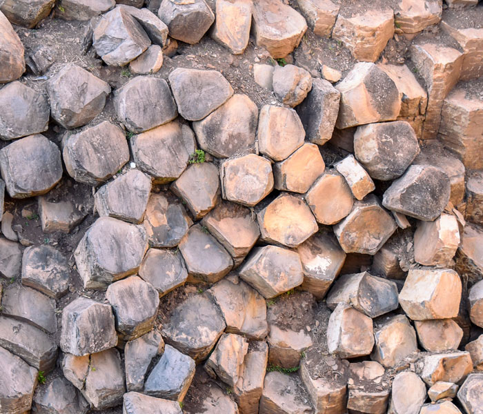
The Basaltic Prisms are the emblematic site of the Comarca Minera Geopark, they are located in the ejido of Santa María Regla, municipality of Huasca de Ocampo. The prismatic basalt columns can exceed 40 meters in length and were formed approximately 2.58 million years ago.
The formation of the basaltic prisms is the result of a fluvial current obstructing the flow of lava from the Sierra de las Navajas. When the basaltic lava flow came into contact with a body of water, rapid cooling of the upper and lower surfaces of the flow occurred, isolating the lava body in the center of these two solidified surfaces. The flow of the stream over both surfaces caused a rapid cooling and its constant and homogeneous dehydration, which generated a process of volumetric contraction and disjunction, generating tension fractures that when joined gave rise to prismatic structures of between three, four to eight faces in each column.
GEOLOGICAL ELEMENTS
The basalt rocks formed columns up to 40 m high that now occur on both walls of the main riverbed. They are rocks with pyroxene minerals and some olive-green olivine crystals.
The presence of the 40 m high vertical walls on both sides of the riverbed gives it a spectacular panorama, since to cross it there is a 30 m long suspension bridge.
LOCATION
HOW TO GET THERE?
To get there, take the highway that goes from Pachuca to Huasca de Ocampo (Federal Highway 105), a distance of approximately 34 km. Before arriving to Huasca, take the highway to the basaltic prisms. The trip by car is between 35 to 50 minutes, leaving from Pachuca de Soto.
SERVICES
It has security, parking, restrooms, restaurants, cabins, tourist guide, swimming pool, transportation service, sports field, Comarca Minera Geopark Interpretation Center, among other facilities.