It is located in the barranca de Metztitlán biosphere reserve. Its location offers beautiful night landscapes
LOCATION IN GEOGRAPHICAL COORDINATES
20°16’38.10″N, 98°31’2.26″O
MUNICIPALITY
Huasca de Ocampo
Ejido
San Sebastián La Barranca
GEOLOGIC PROVINCE AND AGE
The igneous rocks are 3 Myr and the sedimentary rocks are 33 Myr. It is located in the provinces: Trans-Mexican Volcanic Belt and Volcanic Belt of Folds and Faults.
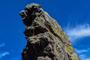
PEÑA DEL AIRE (EL LEÓN VIEWPOINT)
GEOSITE DESCRIPTION
Peña del Aire is located in the Barranca de Metztitlán Biosphere Reserve. From its location beautiful nocturnal landscapes can be appreciated.
Peña del Aire is an extrusive igneous rock of basaltic composition. It is associated with a lava flow resulting from an effusive eruption. Its current state, a rock that is suspended in the air, is due to the physical and chemical weathering that affected the surrounding rocks. The fragments of rock product of the weathering were eroded and transported to the bottom of the ravine, leaving a block of remaining rock with a capricious shape as if suspended in the air, which the settlers called Peña del Aire.
GEOLOGICAL ELEMENTS
Peña del Aire belongs to the Upper Tertiary Basalts Formation. The geological episodes in the area are complex. At the base of the ravine and lava flows there are sedimentary rocks of the limestone and shale type, indicating that the region was under the sea during the Mesozoic. Later the region underwent a process of uplift by orogenic events, so now they are exposed on the surface at an altitude of 100 meters above sea level. Later in the Tertiary, the volcanic events that crown the top of the ravine occurred.
LOCATION
HOW TO GET THERE?
Leave Pachuca towards Huasca de Ocampo along the Corredor de la Montaña highway, upon reaching Huasca de Ocampo take the highway towards San Miguel Regla and continue towards the detour to Peña del Aire.
The duration of the trip from Pachuca to Peña del Aire is approximately 1 hour and 30 minutes.