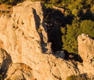
Crag located in the municipality of Epazoyucan, it bears the name of "el guajolote", a native bird, due to a geoform that resembles this bird.
LOCATION IN GEOGRAPHICAL COORDINATES
20° 6′ 33″N, 98° 36′ 9″O
MUNICIPALITY
Epazoyucan
Ejido
El Guajolote
GEOLOGIC PROVINCE AND AGE
2.5 million years
Traquitas El Guajolote
GEOSITE DESCRIPTION
Crag located in the municipality of Epazoyucan, it bears the name “guajolote” (turkey) -a native bird- due to a geoform that resembles this bird. The name “guajolote” comes from the Nahuatl term ‘huexólotl’, which means ‘big monster’.
GEOLOGICAL ELEMENTS
Physical and chemical weathering that affected the igneous rock of trachytic composition. The rock was formed from volcanic activity that occurred 2.5 to 3 Myr.
Peña el Guajolote has a large number of cavities, some of which are full of tridymite and cristobalite. Given its proximity to Cerro de las Navajas, this geosite is rich in obsidian. The predominant rocks in the area are of volcanic origin, lava flows of andesitic and basaltic composition.
LOCATION
HOW TO GET THERE?
Take the highway from Pachuca to Tulancingo, enter the town of El Nopalillo, pass by the Cerro Las Navajas Geosite and continue on the old highway to Mineral del Monte. Peña El Guajolote is located 10 minutes from Cerro Las Navajas.